

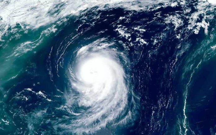
When a hurricane vaults from a modest tropical storm to a Category 5 in roughly a day, the physics of the atmosphere stop being abstract and become a civil-protection problem; Hurricane Polo was exactly that—an extreme, rapidly intensifying cyclone skirting southwestern Mexico with winds at the top of the Saffir–Simpson scale and a rainfall footprint primed for flash floods and mudslides.
At a Glance
- The National Hurricane Center classified Polo as a Category 5 hurricane with maximum sustained winds at least 165 mph.
- The storm’s core lingered near the southwestern Mexico coast while forecast to remain offshore, heightening rain-driven hazards.
- Official guidance emphasized heavy rainfall through Thursday, with flooding and landslide risks along the coastal ranges.
- Polo’s rise qualifies as rapid intensification under NHC criteria and ranks among the eastern Pacific’s most intense recent storms.
What happened: a Category 5 hurricane near the coast, with inland hazards the main story
The National Hurricane Center (NHC) explicitly designated Polo a Category 5 hurricane, the top rung on the Saffir–Simpson Hurricane Wind Scale. Advisory language placed maximum sustained winds of at least 165 mph, with higher gusts; in practical terms, that is a storm capable of catastrophic wind damage if the core intersects land, even as the official track kept the center offshore (and thus the most violent winds mostly over water). The NHC’s position analyses kept the hurricane’s core near the coast of southwestern Mexico through midweek, a configuration notorious for funneling deep tropical moisture onshore while the radius of hurricane-force winds stays largely seaward.
Because water, not wind, drives the deadliest outcomes in many eastern Pacific coastal events, NHC guidance prioritized rainfall and hydrologic effects. Forecast discussions flagged heavy rain along the coastal states of southwest Mexico through Thursday—conditions that concentrate flood risk in river basins draining the Sierra Madre del Sur, where steep topography converts persistent tropical rainbands into fast-escalating flash floods and debris flows. Local and regional coverage echoed the same risk picture for Guerrero and Michoacán, where saturated slopes and deforested catchments are especially vulnerable to landslides when tropical cyclones “stall and stream” just offshore.
How a storm intensifies this fast: the mechanism and the setup
Rapid intensification (RI) has a precise meaning in operational meteorology: an increase in maximum sustained winds of at least 30 knots (about 35 mph) within 24 hours. By that definition, Polo’s evolution from a 50-mph tropical storm to a Category 5 hurricane meets the RI threshold decisively. The ingredients were textbook: very warm upper-ocean heat content, high mid-level humidity, and low vertical wind shear. Those three alignments allow a compact inner core to tighten, the central pressure to fall rapidly, and the eyewall’s convective ring to organize and symmetrize—each step feeding back positively into the next, with air descending in the eye warming and drying, and outflow aloft ventilating the tower of thunderstorms enclosing the center.
The eastern Pacific is a frequent stage for RI because oceanic and atmospheric conditions conducive to such bursts occur more regularly there than in the Atlantic. The NHC’s own glossaries and research program materials have standardized the 30-knot/24-hour benchmark for decades, and synthesis reports have documented that a large fraction of major hurricanes exhibit at least one RI phase. Polo tracked the pattern: a compact, well-ventilated inner core over high ocean heat content, then a jump in winds and a deep pressure fall as the eyewall solidified. Contemporary reporting cited reconnaissance-supported peaks near 180 mph—higher than advisory-time winds—illustrating the challenge of pinning a single “peak” as the vortex evolves from pass to pass; in real time, the NHC publishes discrete snapshots, then refines the record in a post-storm analysis.
Why “offshore” still floods you: terrain, moisture, and training rainbands
An offshore track can be deceptive comfort. The hydrologic consequences are governed less by the radius of hurricane-force winds than by the volume, duration, and orientation of moisture transport. With Polo, persistent onshore flow lofted deep tropical moisture up the coastal ranges. Orographic lift—air forced upslope by terrain—wrings out that moisture efficiently, turning a conveyor belt of rainbands into prolonged, intense rainfall episodes. Even where well-anchored soils can absorb initial rain, antecedent wetness and steep slopes quickly erase that buffer; when thresholds are crossed, landslides initiate on ridgelines and channelized debris flows accelerate in ravines and riverbeds, often well downstream of the heaviest hourly rates.
The NHC captured that risk succinctly in its forecast discussions: heavy rainfall through Thursday for coastal southwest Mexico. That is the load-bearing sentence for public safety: if the core remains offshore but the plume remains onshore, your hazard is water—flash floods in urbanized lowlands and mudslides on saturated slopes. Mexican civil-protection agencies typically translate this guidance into local alerts and, when warranted, evacuation notices; media reports in the period pointed to flooding and landslide potential in Guerrero and Michoacán consistent with past analogous setups.
Intensity records, numbers in flux, and how to read them
Two realities coexist during an RI event. First, the top-line story—Polo reached Category 5 strength near the coast—is unambiguous in NHC advisories. Second, the exact peak wind and central pressure evolve on sub-daily timescales, and numbers cited across outlets reflect different observation windows. Advisory snapshots listed 165-mph sustained winds; some reports referenced 180 mph and exceptionally low central pressures as aircraft reconnaissance sampled the core between advisories. That divergence is not contradiction; it is the signature of a strengthening system observed at different times and depths of the vortex. The NHC later reconciles these with a best-track analysis; during the event, hazard messaging remains anchored to the advisory suite—the authoritative, time-stamped baseline.
It is also fair to situate Polo within the basin’s climatology. Eastern Pacific giants—Patricia (2015) most prominently—set extraordinary benchmarks. Contemporary expert coverage framed Polo as among the strongest on record for the basin, and certainly an outlier for intensification pace. But what matters for decision-making is not the superlative; it is where the core goes and how long the moisture train persists. With Polo, the forecast emphasized “near the coast, staying offshore,” and “heavy rainfall impacts through Thursday.” That pairing is the signature of a flood-first threat profile.
Preparedness takeaways that don’t expire
Three practical lessons apply whenever an eastern Pacific hurricane intensifies near the Mexican littoral. First, track and hazard are different dimensions: offshore tracks can still deliver life-threatening floods in mountainous terrain via moisture convergence and orographic enhancement—plan as if the water is the hazard until the core jogs decisively out to sea. Second, in rapid intensification windows, expect advisory-to-advisory changes in top-line numbers; use the NHC advisories as your operational reference, not social media fragments of reconnaissance feeds out of context. Third, translate “heavy rainfall through Thursday” into specific local actions: clear drainage, pre-position supplies and medical needs, identify upslope risk zones, and avoid river crossings during and after peak bands, when delayed debris surges can arrive without new rainfall overhead.
Hurricane science has advanced markedly—satellite microwave sounders, aircraft Doppler radar, and improved ocean heat content analyses now detect inner-core changes hours earlier than a generation ago. Yet forecasting the onset and magnitude of RI remains one of the field’s hardest problems because it hinges on small-scale processes embedded in a vast, evolving environment. That is why the eastern Pacific will continue to produce storms like Polo: compact cores over deep warm water, low shear, and efficient outflow aloft. For coastal communities from Michoacán to Jalisco and Guerrero, the enduring wisdom is to treat the rainfall guidance with the same gravity as wind categories. The number on the scale tells you how strong the engine is. The hydrology tells you what it will do to your valley.
🚨 Hurricane Polo Update: One of the strongest storms ever is churning off Mexico’s Pacific coast, raising concerns as it intensifies. 🌊🌀 Get the latest details, track the storm and see what’s next 👇 https://t.co/Wh4tN1phOA #HurricanePolo #Mexico #Storm pic.twitter.com/Tx8pZd6U16
— La Amelia (@LaAmeliajo) September 23, 2026
Sources:
nypost.com, nhc.noaa.gov, cnn.com, weather.com, foxweather.com