
Hurricane Isaias blasted Florida’s Panhandle with hurricane-force winds and dangerous surge, flooding yards and streets as the storm came ashore near Destin.
Story Highlights
- Broadcast reports described landfall near Destin with hurricane-force winds, surge, and flooding.
- Meteorologists cited wind gusts over 100 miles per hour around the Panhandle.
- Reports noted surge near five and a half feet and rainfall near nine inches around Fort Walton Beach.
- National Hurricane Center advisories documented Hurricane Isaias warnings for Florida.
Powerful Landfall Brings Wind, Surge, and Flooding
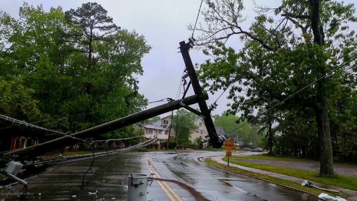
Local television reports said Hurricane Isaias made landfall near Destin with strong winds, large waves, and rising water. Video showed storm surge pushing into low-lying yards and streets. Reporters described roof damage, downed trees, and power outages in communities across the Panhandle. Widespread debris made many roads hard to pass. Emergency crews urged people to stay off the streets until winds eased and high water started to drop. Officials warned that hidden hazards, like downed lines, could linger after the eye passed.
Named meteorologists on air referenced wind gusts well above tropical-storm strength across the area. A Houston-based broadcast cited a reported 102 mile-per-hour gust at Pensacola City Hall and up to 116 miles per hour in Destin. Those numbers match the damage pattern seen in scattered roof failures, snapped limbs, and toppled trees. Crews also worked around local power flashes as lines came down. Utilities began staged repairs once conditions were safe enough for bucket trucks to roll.
Water Levels and Rainfall Exacerbate Damage
Broadcasters relayed gauge readings of storm surge near five and a half feet and rainfall totals near nine inches around Fort Walton Beach. Water pushed through bays and sounds and spilled into neighborhoods. Reporters said the storm drove destructive waves on top of the surge, which worsened shoreline erosion. A flash-flood alert covered Okaloosa County into the early morning, as bands kept training over the same areas. Drivers faced stalled cars, blocked routes, and fast-moving water that could sweep people off their feet.
Surge hazards differ from normal tides and wave run-up. The National Hurricane Center defines storm surge as the rise of water above the expected tide driven by a cyclone’s winds. Even a few feet of surge can flood homes, cut power, and trap families. The Center warns that life-threatening inundation can occur inland from the shoreline, especially along canals and bays. That explains why areas away from open beaches still saw deep water during the peak of Isaias’s push.
Official Advisories and Warning Infrastructure
National Hurricane Center advisories earlier identified Hurricane Isaias and issued hurricane, tropical-storm, and storm-surge alerts for parts of Florida as the system approached. The advisory language explained expected hazards, including dangerous winds, heavy rain, and coastal flooding. Those advisories also described the storm’s structure and motion, which set up Panhandle impacts as the system neared the Gulf Coast. The warnings gave local officials and residents time to secure homes and plan for outages and high water.
At least one person in Florida was killed by Hurricane Isaias’ landfall in the Panhandle Friday night.
Details: https://t.co/bcXYyjZINA #KHON2 | #WorkingForHawaii pic.twitter.com/W7h0YNCXpJ
— KHON2 News (@KHONnews) October 10, 2026
Subsequent discussion products from the National Hurricane Center detailed the storm’s evolution and how threats could shift as the center moved. Forecasters stressed that wind and surge can extend far from the exact landfall spot. That means towns beyond the eyewall could still face tree damage and flooding. Local stations reflected those warnings, describing debris across counties and flush crews rotating into the field as bands eased. The shared message: wait for all-clears before venturing out.
Why This Matters for Communities and Policy
Storms like Isaias expose how close many families live to the edge. One hit can wipe out savings, flood a small business, and shut a school for days. People across the political spectrum want basic competence: clear warnings, sturdy power grids, open roads, and honest updates. When systems fail, recovery drags, and trust erodes. Better hardening, clearer surge maps, and faster outage response are not partisan. They are the backbone of public safety and a fair shot at the American Dream.
Sources:
facebook.com, weather.gov, star.nesdis.noaa.gov, nhc.noaa.gov